

by Greenbelt Online editor Susan Harris. Published March 15, 2020.
As a regular outdoor walker for exercise and the sheer pleasure of being outdoors, I’d been frustrated in my search for walking routes around Old Greenbelt. My own attempts had resulted in deadends, stretching of walking in the street and the occasional scarily aggressive dog. So when Matthew Swanson commented on a Greenbelt Facebook group that he had a great walking route through Old Greenbelt I was jumped at the chance to ask for details – preferably a map.
Residential Old Greenbelt Route – 2.6 Miles

He agreed and soon posted this map to Facebookers, saying, “You get to see all the different types of housing. The only time I walk on a road is to cross a street, otherwise it’s all on paths. It’s about 2.6 miles around.”
It only took two tries for me to follow the map correctly and sure enough, no obstacles, deadends or walking IN the street (just crossing it).
Walking around Greenbelt Lake
The Greenbelt Museum suggests several walks, especially for first-time visitors to Old Greenbelt: “This walk makes a 1.5 mile circuit from the Community Center around scenic Greenbelt Lake without crossing any roads! The path around the lake is mostly flat, shaded, and is maintained with a crushed stone surface. See the interpretive panel at the lake located near the picnic area.” Locals know this route well and may be, like me, eager for a change.
- Exit the Community Center toward Roosevelt Center. Turn left by the Aquatic Center and walk down the access road on your left toward the Youth Center.
- Go past the Youth Center (on your right) and turn right toward Braden Field.
- Follow the path along Braden Field past the tennis courts.
- Take the Lake rail East Entrance and walk the past that circles around the lake.
- Return the same way. (Approximately 1.5 miles)
Walking through BARC

The Museum also recommends walking through “the Farm.” That’s the Beltsville Agricultural Research Center, which is easily accessible from Research Road in Old Greenbelt and is perhaps more popular with cyclists than walkers, but still… lots of acreage to explore! From the Museum site:
“Walkers wanting a longer stroll and bicyclists will appreciate the wide open country on this route that takes you into the U.S.D.A.’s farm adjacent to Greenbelt. This walk is only recommended on weekdays after 6:00 p.m. and on weekends and holidays when the portion of Research Road that enters the Beltsville Agricultural Research Center is closed to car traffic. This farm road offers lovely vistas of the farm. Walking in the fields is not permitted. The farm begins on Research Road, which intersects with Ridge Road just past Greenbelt Elementary School. (Approximately 1 mile to farm entrance from the Community Center.)”
As for recommended routes through BARC, ones that are safe for pedestrians and of known distances, I’m at a loss except to ask for suggestions among readers. I’m hoping to update this post soon with more detailed recommendations.
Hiking the Greenbelt North Woods

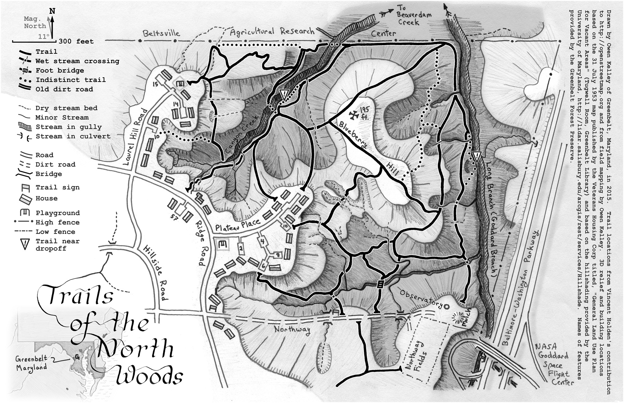
I also heard about a super-helpful project by Greenbelt’s top North Woods ecologist – Owen Kelley, whose Field Guide to the North Woods was the prize for the very popular give-away we did on this blog. And for this post he offered tips for how to use the map and hike the trails.
Tips from Owen Kelley.
“Here is a map I created in 2015 showing two loops, about a mile each, on Laurel Hill and Blueberry Hill, starting in GHI woodlands and going into the “North Woods” of the Greenbelt City Forest Preserve. The paths on Laurel Hill are less used and may be harder to follow, and require crossing the stream, going down into the streambed and back up. The paths start from the Canyon Creek Trail, next to 58 Ridge Road, but you can also go in from the Forest Preserve sign on Northway Road. (Download larger version here.) The trail network has mostly stayed the same in the past five years I do find that map useful and I often take a copy with me when I hike.”
.)

Owen continues, “An alternative map that is also useful is my ecology map of the North Woods that I included at the back of my recently published field guide (shown above). This eco-map shows holly and mountain laurel patches and other plants that can help you keep track of your location when hiking in the North Woods. The eco-map hints at terrain and trails while emphasizing plants.”

Owen has two suggestions for readers taking their first hike in the North Woods:
- Any time of the year, I recommend the trail that starts at the back of the playground at the terminus of Laurel Hill Road (between 14 and 15 Courts). At the first two forks in the trail, keep to the right, which will take you through a beautiful and dense holly grove on the way downhill to Canyon Creek. The lay of the land is rather beautiful downstream along Canyon Creek as you walk to the fence of the Beltsville Agricultural Research Center. On your first hike, just retrace your steps to get back to Laurel Hill Road because the other trails can be a bit hard to follow.
- When the mountain laurel blooms in May, plan on taking the trail that starts at the end of 10 Court Plateau Place then goes counterclockwise over the summit of Blueberry Hill, exiting the forest at the end of Plateau Place near 12 Court.
He writes that “One advantage of these two routes is that they mostly avoid dense patches of multiflora rose that affect the low land near Northway Road (the dirt road) and they avoid the dense poison ivy along the upper portion of the Canyon Creek trail that starts between 58 and 62 Courts of Ridge Road.”
For the “more adventurous,” Owen recommend a third hike route:.
- In April, take a trail of your choice to reach the western bank of Goddard Branch. It’s in April that you’ll discover an impressive patch of spring beauty in bloom and a nice grove of spice bush in bloom if you hike the full length of the trail along the western bank of Goddard Branch within the North Woods.
General Tips for North Woods Hikers
“And it is always good to repeat that one should wear tick repellent when hiking in Maryland, and be on the lookout for poison ivy even though it is uncommon in most densely wooded places.
“Lastly, I recommend taking a trail map with you in the North Woods. It is a much more “wild” experience than walking along the kind of paved walk/bike paths that the county maintains elsewhere or even the well-maintained, wide, blazed footpaths in the National Park Service’s “Greenbelt Park.” The North Woods gives you more of a wilderness experience, and in exchange, you have to accept the fact that you will probably become temporarily confused about your location every now and then, even after you have hiked the North Woods a few times. We are so lucky to have a place this wild close to our homes.”
Worried about Getting Lost in the Woods?
I asked Owen if he knew of an app that North Woods hikers could use for guidance and he suggested we ask Catherine Plaisant. She responded:
“The general answer is any app that uses OpenStreetMap. Someone local nicely entered the trails in OpenStreetMap several years ago. You do have to make sure OpenStreetMap is selected as one of a layer for the map. For example, these apps work for our trails: Gaia, Mapmyrun and AllTrails.
“You may want to remind people that since the trails are not maintained and trees fall all the time, trails may have changed and it is easy to get confused going around large recent tree falls. So if you don’t have a good sense of orientation, just turn around and try another trail.”
Running Trails for Walkers, Too

Check out the MapMyRun page for Greenbelt to find a variety of routes through Old Greenbelt, ranging from 1 to 15 miles. As best I can tell, users of the map click on a number, then zoom in for details. Times given for each route are for running, so probably of no use to us walkers but hey, the distances are exact.
More Walking Routes, Please!
If you know of more good walking routes in or even close to Old Greenbelt, please email them to editor@greenbeltonline.org for review and possible addition to this list. The benefits of walking outdoors have been known forever but now there’s a new one – it’s a relatively safe, socially distant way to get out of the house!