

A black-gum tree lived to an unusually old age in Greenbelt, Maryland, near Research Road and the Beltsville Agricultural Research Center. Within a few years of 1720, this black gum sprouted in an old-growth forest, based on growth rings visible on the tree’s stump and the historical record. In 2018, the black gum died and was cut down. The tree’s growth rings lead us along a path that weaves through Greenbelt’s history.
Introduction
In 2018, a 300-year-old black-gum tree died and was cut down near a home on Research Road in Greenbelt, Maryland. The present article analyzes the growth rings visible on the stump when the tree was cut down. In Maryland, three hundred years is a remarkable age for a tree because much of the state was cleared for farming in the 1700s and 1800s.1
The old black gum looked healthy in photos taken one year before it died. The tree’s height and the shape of its branches were unremarkable (Figure 1). They were typical of a tree that had grown deep in a forest all its life rather than in the middle of a field or the sunny edge of the forest.2
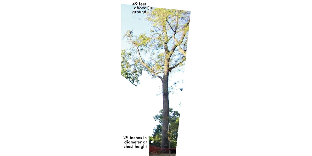
Figure 1. The old black-gum tree near Research Road, as it appeared in 2017.
To a casual observer, nothing about this black gum’s appearance would make it stand out from the presumably much younger trees that surrounded it. In 2018, the trunk’s circumference at chest height was 91 inches, implying a diameter of 29 inches.
A survey of Maryland’s forests gives us a clue that this black gum was unusual. In 2019, the US Forest service surveyed Maryland’s forests, and they calculated statistics by tree species and trunk diameter. Black-gum trees (Nyssa sylvatica) with trunks 29 inches in diameter were too rare to appear the Forest Service’s statistics. The 2019 survey found that only 13% of tulip poplars (Liriodendron tulipifera) and 2% of white oaks (Quercus alba) had trunks this stout.3
Figure 2 shows the old black gum’s stump as photographed in August 2018, shortly after the tree was cut down. The annual growth rings are so tightly spaced that it is difficult to count them let alone judge the variation in their width without zooming in to one portion of the trunk. Subsequent sections of this article will do just that.
A sequence of photos was used to build the composite image shown in Figure 2. In the composite image, the author marked with small triangles 290 annual growth rings. Approximately 8 additional rings would fit in the small gap between two of the photos. It is possible to estimate the number of missed rings because of the ruler along one edge of the photos. Several more rings too faint to count would fit in the inner-most half inch of the trunk. In total, the count reaches 300 rings, give or take a few.4
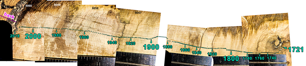
Figure 2. Growth rings on the stump of the old black gum that grew near Research Road in Greenbelt, Maryland. The sequence of photos was taken in August 2018. To show the rings more clearly, zoomed-in portions of this image are shown in Figures 5, 6, and 8.
Black gum growth rings are challenging to count even if one sands the wood or uses a plane to smooth it. Black-gum rings lack the line of pores that mark the earliest wood that an oak tree grows each year. To illustrate this difference, the author photographed up close a black-gum and oak branch (Figure 3).5
While it is a challenge to interpret the varying widths of growth rings, just the trunk diameter and number of rings tells us something. As stated above, the trunk was 29 inches in diameter and the tree lived approximately 300 years, which means an average ring width of 1.2 millimeters per year. This is a bit less than the width of a penny. This growth rate is within the range that is typical of a tree inside a forest, where competition for light and moisture is fierce. This growth rate is much slower than for a hardwood tree that faces minimal competition because it grows in a field, pasture, or lawn, or along a road.6
Before examining specific periods of this black gum’s life, the next section speculates about the forest in which the black gum sprouted about three centuries ago.

Figure 3. Close-up images of the wood grain of a black-gum and oak branch (left and right). The earlywood of each annual growth ring is marked with a blue arrow. Growth rings are less distinct in black gum than in oak.
The Old-Growth Forest
Circumstantial evidence suggests that the 300-year-old black gum sprouted in an old-growth forest. Generally speaking, hardwood forests migrated north into Maryland about 11,000 years ago. Before that, hardwood forests had temporarily retreated south to the Gulf Coast to avoid the cold temperatures of the ice age that ended about 11,000 years ago.7
According to archaeologists, Greenbelt lacked year-round inhabitants for thousands of years before European settlers arrived. The lack of a major human settlement here meant that the forest that covered much of Maryland back then probably covered this part of Greenbelt too.
Based on several archaeological digs in the Greenbelt area, Native Americans only visited Greenbelt seasonally to gather food. As far as we know, their permanent settlements were located downstream in the main tributaries of the Chesapeake Bay and along the Chesapeake Bay’s shore. By 1695, Europeans has largely driven Native Americans out from the lower Potomac and Prince George’s County.8
Putting all this information together, the 300-year-old black gum most likely sprouted in what can safely be called an old-growth forest. In the Eastern United States, “old growth” is a term usually applied to a forest that has avoided major disturbances for several centuries. A major disturbance would be something like lumbering that clear cuts an area or a fire intense enough to kill all trees over many acres.9
The patch of forest in which this black gum sprouted likely remained old growth for at least another 75 years. This guess is reasonable because the rings on the stump date back to about 1720 and no one purchased this land until 1795. Before 1795, the land remained in the general pool of land owned first by the British colony of Maryland and subsequently by the State of Maryland. In contrast, the land 200 to 1,000 feet away in every direction became privately owned much earlier, during 1695–1763.
Figure 4 is a map that shows private land ownership near the old black gum in 1770. The different land parcels are shaded in different colors. To provide context, today’s roads are overlaid in gray. The location of the black gum is marked with a green dot near the top of the map. When an individual purchased a land parcel from the government, the individual named it and the land office issued a document that stated the property’s boundary line. In the 1770s, the old black gum was surrounded by land parcels with the following names and purchase years: Friendship (1695), Addition to the Hope Enlarged (1763), Prathers Grove (1719), and Snowdens Discovery (1760). For details, see Appendix A of the PDF version of this blog post.

Figure 4. A modern-day street map of Greenbelt (gray) overlaid with private property in 1770 (colored areas) as described in Appendix A. The location of trees alive in the 1870s are marked with green dots, along with the tree species and the year of the oldest visible growth ring, as described in Appendix B. The brown lines are the location of roads in 1870s, as best as can be determined from old maps.
One can speculate that the 40 acres on which the old black gum grew was unclaimed for so long because the parcel was less desirable for farming and settling than the surrounding stream valleys. These 40 acres sit on a dry ridge that is about a hundred feet higher in elevation than the land in most directions.10
The Young Black Gum
The black gum grew rapidly during its first four years. When the tree was about 10 years old, it was wounded sometime during 1731–1733. At that time, the trunk was only about 1.5 inches in diameter at ground level.
During subsequent years, rot spread inward from the wound toward the center of the trunk. Meanwhile, the tree grew very slowly during 1740–1762, perhaps because of the wound. The tree worked from both sides to close the wound by growing wood called “callus growth.” Both sides of the callus are labeled in Figure 5. By about 1758, the black gum succeeded in covering its wound with bark and healthy wood. The rot was encapsulated and did not spread to the rest of the trunk.11
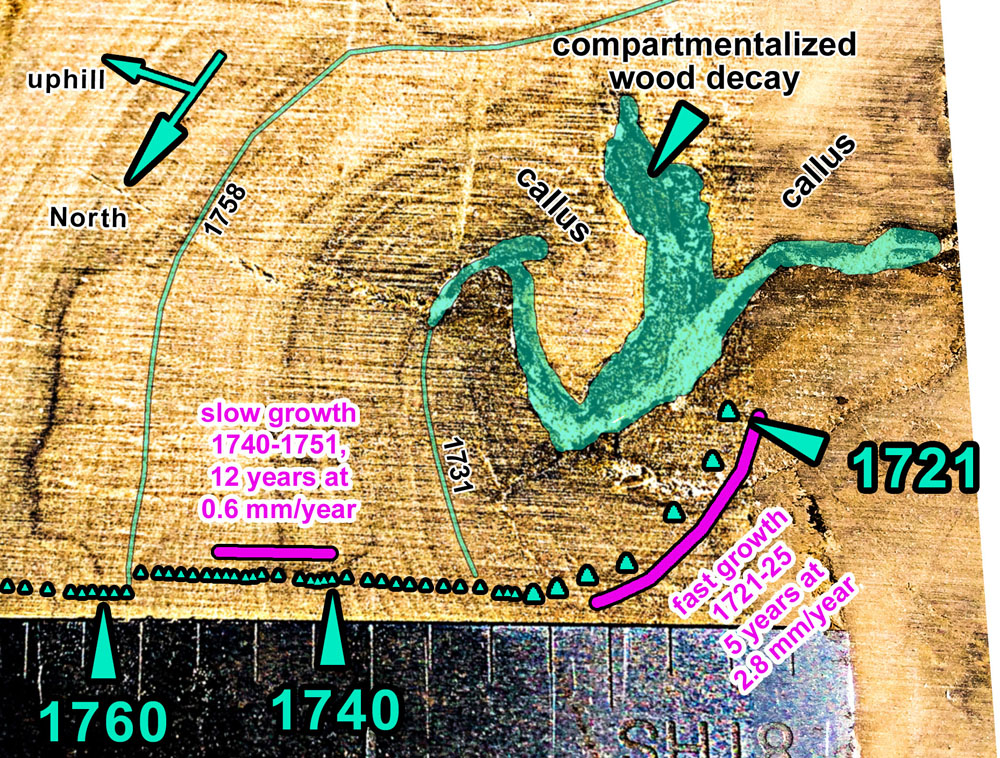
Figure 5. A zoomed-in view of the central portion of the stump of the old black gum.
It is unclear if the black gum’s 1731 wound was caused by a fire or some mechanical process such as a falling branch. We have a record of the wound at ground level because that is the height at which the tree would be cut down many years later. A wound at this height is consistent with a brush fire. A brush fire is a type of forest fire that burns at low intensity and consumes undergrowth but allows many trees to survive. Black gum is better than most tree species at surviving brush fires.12
By the late 1700s, the black gum was once again growing at a healthy rate for a tree in a forest. The black gum had an uneventful life for the next a century. The width of the black gum’s growth rings was unaffected by the founding of our country and the industrial revolution.13
The 1870s Growth Spurt
The story became interesting again when the old black gum had a growth spurt during 1875–1881. Its growth peaked in 1877 with a ring 3.2 millimeters thick, nearly three times thicker than average for this tree. During this period, the black gum was already a mature tree about 160 years old. Figure 6 shows the portion of the stump that grew during these years.

Figure 6. A zoomed-in view of the stump centered on 1877, the year that the tree started a large growth spurt.
It is unclear what caused the seven-year-long growth spurt. Favorable weather during these years, such as plentiful rain or mild temperatures, theoretically could be the cause, but we don’t have precise weather records for Greenbelt that long ago. If the rapid growth had persisted for a decade or two, then the cause might have been a nearby tree falling down and creating a sunny gap in the forest.14
Deepening the mystery, there was something else happening in Greenbelt’s forests around the same time as the old black gum’s seven-year growth spurt (1875–1881). In this part of Greenbelt, very few trees survived to the present that sprouted before the 1870s, but many trees survived to the present whose stumps have growth rings in the 1870s, 1880s, or 1890s. One could speculate that comparatively more trees were sprouting in Greenbelt starting in the 1870s or the survival rate was higher for these trees than for trees that sprouted before then.
The scarcity of pre-1870s trees in Old Greenbelt is a pattern that emerges from admittedly haphazard sampling. Specifically, it is seen in a collection of 17 trees that residents have found cut down in the past 6 years (Appendix B of the PDF version of this blog post). In general, Greenbelt Homes Inc. (GHI) and the city’s Public Works Department cut down trees near homes or roads when they are severely storm damaged or declining in health.
The sprouting of many hardwood trees in the late 1800s could be an ecological response to the reduction in farming activity in Greenbelt during the Civil War (1861–1865) and afterward. Field abandonment starts the natural process of reforestation. Typically, fast-growing sun-loving “pioneer” tree species come first, such as pine and black locust. A decade or two later, shade-tolerant hardwoods, like oak and black gum, proliferate in the shade cast by the pioneer trees.15
Alternatively, the sprouting of many hardwood trees in the late 1800s could be the forest’s response to limited timber harvesting. Tree seedlings proliferate when some trees are harvested and other seed-bearing mature trees are left standing. Such “culling” events are known to have occurred in this part of Prince George’s county.16
When loggers cull a forest, they cut down the economically valuable trees, leaving the younger trees, crooked trees, and less valuable species. In the 1800s, black gum was a species with little economic value. A 1913 survey of Prince George’s County reported that essentially all of the county’s forests had been culled in this way.17
Greenbelt is Built
The Great Depression started in 1929, and a small part of the federal government’s response involved purchasing in 1933 the land on which the old black gum grew. Two years later, the federal government bought most of the rest of the land that would become the town of Greenbelt in 1937. During this process, the old black gum avoided the ax through luck. The tree just happened to be growing within the belt of forest and field that federal planners intended would surround the model town in perpetuity.18
As part of his New Deal program, President Franklin Delano Roosevelt (FDR) approved his advisors’ ideas for building several “greenbelt towns,” including Greenbelt itself. The design principles for Greenbelt in particular were influenced by the “garden city” model of town planning that featured a belt of green space around the residential and commercial core.19
Two expressions of the New Deal plan for Greenbelt are found in maps produced by federal planners in 1936. One map showed Greenbelt roughly as it would be constructed during 1935–1937. The other map added hypothetical additional construction that reflected the original design principles.20
After digitizing these two New Deal era maps, the author added a star symbol to mark the location of the old black-gum tree (Figure 7). These two maps implicitly or explicitly locate the old black gum in the belt of green. In the upper map, the black gum is 500 feet off the edge of the map in what the map implies would be the Agricultural Research Center. In the lower map, the black gum is located in a forest a few hundred feet north of the residential area.
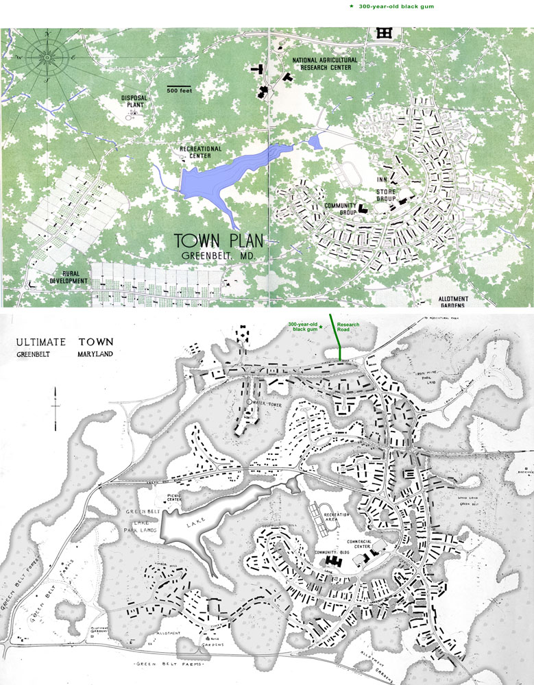
Figure 7. Two New Deal era maps of Greenbelt. The upper map shows the initially planned 1930s construction. The lower map is a rendering of how the town might look after it finished growing years later. The author added a green star to each map to indicate the location of the old black-gum tree. In the lower map, the author added shading to emphasize the location of woods because the original 1936 map only hinted at the woods’ edges with faint lines.
The width of the black gum’s growth rings remained unchanged during the years that the federal government constructed the first New Deal neighborhood (1935–37). The black gum’s steady growth suggests that the grove in which the old black gum grew was unaffected by the construction.
During 1941–1955, the black gum grew faster than it had during prior decades of the 1900s. The portion of the stump that grew during these years is shown in Figure 8. During the later part of this period (1949–1955), the black gum adding girth to its trunk twice as quickly as it had in 1940.

Figure 8. The portion of the black gum’s stump that shows the wood that grew during the growth spurt that peaked around 1950.
Near the black gum, two things happened within a decade of the black gum’s circa-1950 peak growth. It is unclear if either of these events affected black gum’s growth rate. In 1941, Greenbelt’s second New Deal neighborhood was built 200 feet south of the old black gum. But this construction seems too far away to explain the black gum’s 1950 peak growth rate. A 1965 aerial photograph shows an unpaved footpath passing within 10 feet of the old black gum. This 1965 footpath is absent in aerial photographs taken in 1938 and 1977. It is unknown if the path existed in 1950.21
The black gum was not alone in experiencing rapid growth around 1950. A somewhat similar pattern is seen in the growth rates of 17 other old trees that were cut down recently in this part of town (Appendix B). Among this set of trees, the general pattern is that many of them experienced slower than average growth during 1922–1935 and faster than average growth during 1945–1981.
In 1959, the leaders of the town’s housing cooperative sold to investors and developers most of the belt of green near the New Deal era housing. This forested land subsequently changed hands multiple times, but the old black gum remained undisturbed. For several decades, aerial photos show no construction or other change in this corner of the forest.22
The Forest in Recent Decades
It is remarkable how long this black gum’s luck lasted even as Greenbelt became more densely developed. Several residential neighborhoods were built in Old Greenbelt during the 1960s.23
As the DC suburbs became more densely developed, some Greenbelt residents pushed for the town to preserve green space. In the 1960s, there was a revival in interest in Greenbelt’s New Deal design principles. Residents and the town council worked to preserve the patches of forest between neighborhoods and larger tracts elsewhere, such as around Greenbelt Lake and the remaining portions of the original belt of green.24
None the less, home construction continued. Along Research Road, the seven acres of forest that contain the black gum were divided into lots for single-family homes in 1984. On this land, trees were left standing so that the homes would have wooded lots.25
Between 1984 and 1998, single-family homes were built on all these lots along Ridge Road except for the one lot where this old black-gum tree was growing.26
Meanwhile, various protections were put in place, bit by bit, for what was left of the town’s namesake, the belt of green. For example, the City of Greenbelt ultimately purchased or otherwise acquired 236 acres of forest between Ridge Road and the Baltimore-Washington Parkway by 1991. These woods lay along the eastern border of the woodlands already owned by Greenbelt Homes Inc. (GHI). Together they formed a continuous forest. In 2003, the city-owned portion of this forest was designated a Forest Preserve.27
The western edge of this GHI and City forest was only a quarter mile from the old black gum. This distance was spanned by the woods behind Greenbelt Elementary (owned by the county) and woods owned by homeowners.28
In 2016, construction started on a home on the lot where the old black gum grew. As was the case when other homes in this neighborhood were built, care was taken to avoid harming the mature trees on this lot. The reason is unknown why the old black gum rapidly declined in health in 2018.
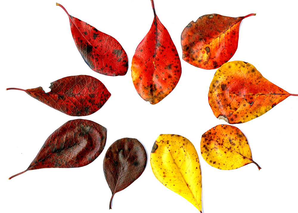
Figure 9. A selection of fall colors from a black-gum tree in Greenbelt.
Final Thought
In a sense, we are lucky that this black-gum tree grew in what became a residential neighborhood. Near homes and roads, dead trees are cut down for safety reasons. A side effect of cutting down an old tree is that its stump reveals the tree’s annual growth rings. It is like opening a time capsule that has been sealed for a century or longer.
In contrast, in the middle of a forest, a dead tree is left standing for economic and ecological reasons. Cutting down a tree is expensive, and leaving dead trees standing improves forest health. Standing deadwood provides habitats for animals, plants, fungi, and other living things. When such a tree eventually falls down, it further decomposes and returns nutrients to the soil. Had the old black gum grown deep in a forest, there would have been little chance of us discovering its old age.29
Black gum, also known as Nyssa sylvatica, is a tree species known to live for centuries under the right conditions. It is exciting to find a tree in Greenbelt that lived 300 years. This black gum sprouted so long ago that its early years were likely spent growing in an old-growth forest.30
References
Abrams, M. D., April 2007: Tales from the blackgum, a consummate subordinate tree. Bioscience, 57, 347–359.
Agricultural Adjustment Administration, May 11, 1935: Preliminary plat compiled from aerial photograph and certain land records, Berwyn Area. U.S. Land Acquisition Department, Agricultural Adjustment Administration (AAA). Available in the Tugwell Room special collection, Greenbelt Branch, PG County Memorial Library System.
Arnold, J. L., 1971: The New Deal in the Suburbs: A History of the Greenbelt Town Program, 1935–1954. Ohio State University Press. Available in the Tugwell room of the Greenbelt public library.
Besley, F. W., 1913. The Forests of Prince George’s County. Maryland State Board of Forestry, 41 pp. Available at University of Maryland Hornbake Library Maryland Room.
Clatterbuck, W. K., 2006: Tree Wounds: Response of Trees and What You Can Do. pamphlet SP683, U. Tennessee Cooperative Extension Service.
Curtin, P. D., G. S. Brush, and G. W. Fisher (Eds.), 2001: Discovering the Chesapeake: The History of an Ecosystem. John Hopkins U Press, 385 pp.
Davis, M. B. (Ed.), 1996: Eastern Old-Growth Forests: Prospects for Rediscovery and Recovery. Island Press, 383 pp.
Frelich, L. E., and P. B. Reich, 2003: Perspectives on development of definitions and values related to old-growth forests. Published on the NRC Research Press website, http://er.nrc.ca. Presented the “Old-Growth Forests in Canada: A Science Perspective” conference, Ontario, 2001.
Fulmer, O. K., 1941: Greenbelt. American Council on Pubic Affairs, Washington DC., 46 pp. Available at the Tugwell Room of the Greenbelt Public Library and online at https://babel.hathitrust.org/cgi/pt?id=mdp.39015037299719;view=1up;seq=3.
Hoadley, R. B., 2000: Understanding Wood: A Craftsman’s Guide to Wood Technology. The Taunton Press, 280 pp.
Kelley, O. A., 2023: A Black-Gum Tree Lived 300 Years in Greenbelt, Maryland. Greenbelt Online blog, the extended version of the present blog post, PDF file.
LeeDecker, C. H., and B. Koldchoff, 1991: Excavation of the Indian Creek V Site (18PR94): An Archaic Gathering Camp in the Maryland Coastal Plain. Final Report, Louis Berger and Associates, Inc., 318 pp., https://apps.jefpat.maryland.gov/NEH/Assets/Collections/images/18pr94/PDFs/excavation_of_the_indian_creek_site.pdf. The Archaeological Collections in Maryland website has information about this and other sites: https://apps.jefpat.maryland.gov/neh/.
Leverett, R.: 29 Dec 2002: email to Colby Rucker in thread titled “Forest Structure and Old Growth Definitions.” Posted to “Colby’s Corner” on the Eastern Native Tree Society website, http://www.nativetreesociety.org/corner/index_corner.html. Quote: “What most of us are really looking for are forests that have been developing under the complete dominance of natural processes for a long time—at least 150 to 200 years and preferably longer. During that time many natural cycles repeatedly play out. Young trees have the opportunity to mature and take on old-growth forms. The litter layer has a chance to develop. Niches form to accommodate more types of small animals and plants. The whole forest takes on a look that most of us have been sharpening our skills at recognizing for years. What especially interests us about these “old growth” forests is the richness of life and complexity of process and of forest structure. Old growth ecosystems are far more diverse and interesting than the tightly controlled forests that are intentionally simplified to produce crops. But the richness and complexity of what we label old growth does not manifest itself well, if the forested areas are too small. What is often preserved as old growth are small 25 to 100 acre tracts that are under assault from all sides. We may value the small areas for historical reasons, but ecologically, they are vulnerable—especially those in semi-urban areas.”
MD DNR, 2015: Sustainable Forest Management Plan for Chesapeake Forest Lands, revision #9. Maryland Department of Natural Resources, 226 pp, https://dnr.maryland.gov/forests/Documents/chesapeake/CF-SFMP_2018.pdf.
Namorato, M. V., 1992: The Diary of Rexford G. Tugwell: the New Deal, 1932–1935. Greenwood Press.
Parsons, K. C., 1990: Clarence Stein and the Greenbelt Towns. J. American Planning Association, 56, 161–183.
Parsons, K. C., spring 1998: Clarence Stein’s variations on the Garden City theme by Ebenezer Howard. APA Journal, 129–130.
Pedersen, B. S., and J. L. Howard, 2004: The influence of canopy gaps on overstory tree and forest growth rates in a mature mixed-age, mixed-species forest. Forest Ecology and Management, 196, 351–366.
Rentch, J. S., F. Desta, and G. W. Miller, 2002: Climate, canopy disturbance, and radial growth averaging in a second-growth mixed-oak forest in West Virginia, U.S.A. Canadian J. of Forest Research, 32, 915–927.
Resettlement Administration, 1936: Greenbelt Towns, 32 pp.
Resettlement Division of Farm Security Administration of US Department of Agriculture, Jan. 6, 1938: Project Land and Acquisition Costs for Tracts Accepted Classified According to Counties and Purchasers (G-In Greenbelt Corp. Limits). a 6-page table, form FSA-RP 29. folder labeled “correspondence land acquisition” in box 4 of 5 in series “Disposition Docket Files Relating to Greenbelt, Maryland, 1947–1955,” NAI #7419858, record group #196, National Archives.
Rice, J. D., 2009: Nature and History in the Potomac Country. John Hopkins U. Press, 338 pp.
Skolnik, A. M. (Ed.) et al., 1962: City of Greenbelt 25th Anniversary, 1937–1962. Greenbelt Silver Anniversary Committee, 48 pp. Available at the Prince George’s County Historical Society library and the Tugwell Room of the Greenbelt public library.
Snyder, M., 2015: Woods Whys: How Do Trees Heal Wounds on Trunks and Branches? Northern Woodlands website, https://northernwoodlands.org/articles/article/woods-whys-how-trees-heal.
Speer, J. H., 2010: Fundamentals of Tree-Ring Research. U Arizona Press, 333 pp.
Stein, C. S., 1951: Toward New Towns for America. U Press of Liverpool, 245 pp.
Thomas, P. A., and J. R. Packham, 2007: Ecology of Woodlands and Forests. Cambridge U. Press, 528 pp.
U.S. Forest Service, 2020: Forests of Maryland, 2019. Resource Update FS-246, U.S. Department of Agriculture Forest Service, Northern Research Station, 2-page summary, doi: https://doi.org/10.2737/FS-RU-246. Data tables in an *.xlsx Excel spreadsheet, https://doi.org/10.2737/FS-RU-246-Tables.
Valverde, T., and J. Silvertown, 1997: Canopy closure rate and forest structure. Ecology, 78, 1555–1562.
Wessels, T., 1997: Reading the Forested Landscape: A Natural History of New England. Countryman Press, 199 pp.
End Notes
[1] The old black gum’s location: 39.01350°N, 76.87939°W, near Research Road in Greenbelt, Maryland. The author was unable to find statistics on the population of 300-year-old trees or 300-year-old forests in Maryland. The U.S. Forest Service (2020, Table MD-6) estimated that only 3.2% of Maryland’s forestland is over 120 years old, i.e., tree stands that have gone 120 years without a major disturbance. Only 0.2% of Maryland’s forests are over 140 years old. Much of Prince Georges County was brought under cultivation prior to 1860: Besley 1913, pg. 6.
[2] A tree growing in the middle of a field will likely have a wide form and low branch full of leaves. In a forest, a tree competes to reach the canopy, so it tends to be tall and thin and its trunk lacks low branches: Wessels 1997, pg. 42.
[3] The largest-girth individual-tree category compiled by the U.S. Forest Service (2020, Table MD-11) that contained black gums in Maryland forests was a diameter of 23–25 inches. Only 0.01% of Maryland’s black-gum trees fell in this category.
[4] 2018-1721 +1 +8 = 298 rings. The author lined up the photos so that the growth rings were continuous along the center of the composite image. Due to distortion at the edges of the photos, the ruler along the bottom edge of each photo appears discontinuous in the composite image.
[5] Wood grain: https://www.wood-database.com/ and Speer (2010, pg. 46). According to Hoadley (2000, pg. 67), trees in the genus Tupelo have wood that is “diffuse-porous, growth rings only faintly visible. Pores very small, barely visible even with [x10 magnification] hand lens, evenly distributed.” Various sources claim that the smallest object that can be seen with the naked eye is about 0.05 millimeters across. In Figure 3, the black gum photo was taken with a macro lens, and the oak image is a series photos taken with a microscope at ×40 magnification.
[6] The old black gum’s average ring width of 1.2 mm is calculated from the trunk’s 29-inch diameter, multiplied by 25.4 mm/inch, divided by 300 years, and divided by 2 to convert diameter to radius. In an old-growth forest in Pennsylvania, black gums had an average ring width of 0.75 to 1.25 mm/year (Abrams 2007, Figs. 3, 6, 7). In contrast, two oaks in Greenbelt growing outside the forest, grew rings 7–11-mm thick for decades, as mentioned in Appendix B.
[7] About 15,000 years ago, the North American ice sheet retreated north from Pennsylvania. About 11,000 year ago, the final cold snap of the most-recent ice age (the Younger Dryas period) ended: Curtin et al. 2001, pg. 31, 51. About that time, mixed pine-hardwood forests returned to Maryland: Curtin et al. 2001, pg. 50.
[8] Shortly after the most recent ice age ended, there is evidence of Native Americans living in the Chesapeake Bay area: Rice 2009, pg. 16. Hunter-gatherers used a seasonal site called Indian Creek V (site 18PR94) 10,000–3,000 years ago, i.e., in 8,000–1,000 BC: LeeDecker and Koldchoff 1991, pg. xv. The Jefferson Patterson Park & Museum maintains Archaeological Collections in Maryland (https://apps.jefpat.maryland.gov/neh/) and Maryland Archaeobotany (https://apps.jefpat.maryland.gov/archeobotany/). These websites provide information about site 18PR1024 called “BARC Floodplain A,” site 18PR545 called “Indian Creek Site 1,” and site 18PR546 called “BARC Woods site #2.” Between the 1620s and 1680s, 80% of Maryland’s Native American population died or migrated away. Most of the rest left the Lower Potomac valley by 1695: Virta 1998, pg. 28. When Prince George’s County was established in 1696, the county’s 2,000 European settlers resided primarily along the Potomac and Patuxent Rivers, many miles away from what would become Greenbelt: Rice 2009.
[9] It is unclear how much time must pass after a major disturbance before a forest acquires the biodiversity and other characteristics associated with old-growth forests. Opinions range from 80 to 1,000 years, with most authorities citing several centuries. For example: 80 years (Davis 1996, pg. 6); about a century, meaning older than the age of rotation (Davis 1996, pg. 225); 120 years (Frelich and Reich 2003); 150–200 years (Leverett et al. 2002, email; Davis 1996, pg. 244); 200–300 years (MD DNR 2015, pg. 141); 500–2,000 years (Davis 1996, pg. 360); or under 1,000 years (Davis 1996, pg. 316).
[10] Elevation data: pgatlas.com and USGS topographic maps.
[11] Callus growth and encapsulation: Snyder (2015) and Clatterbuck (2006).
[12] “Black gum is one of the few tree species that combine shade tolerance, drought tolerance, and fire resistance” (Abram 2007). Trees may survive brush fire / surface fire: Speer 2010, pg. 194–205. Brush fires can burn more intensely on the uphill side: Speer 2010, pg. 197. The wound occurred on the east side of the trunk, which is the uphill side.
[13] According to Besley (1913, pg. 6), “Change in industrial conditions following the Civil War also contributed largely to the increase in the forest area. In the western section of the county, at least, much more land reverted to forest during the past forty years [i.e., 1873–1913] than has been cleared.”
[14] Many aspects of the year’s weather may simultaneously affect that year’s growth in a tree, but a single weather variable may act at the limiting growth factor in some cases: Speer 2010, pg. 15-17. Weather affects oak growth rate: Rentch et al. 2002. Small canopy gaps close by the branches of surrounding mature trees growing into the gap by a foot every few years. Larger gaps are filled by existing saplings reaching the canopy in 10-40 years: Valverde and Silvertown 1997, pg. 1560. Canopy trees surrounding a canopy gap have faster radial growth: Pedersen and Howard, 2004.
[15] When agricultural land ceases being cultivated, seeds from nearby trees lead to pine trees colonizing the land before hardwood trees (Besley 1913, pg. 6–7). Black locust is an early successional tree species, i.e., a pioneer species (Wikipedia, Robinia pseudoacacia), and it grows along the forest edge in Greenbelt today (author’s observation).
[16] Besley 1913.
[17] Besley (1913, pg. 8): “Constant culling of the forests for the best of the saw timber ties and poles has also brought about changes in the [forest] types themselves…. In like manner such species as red maple and black gum, comparatively worthless from the timber standpoint, have gained much greater prominence than formerly.” The 1913 map’s legend doesn’t even have an entry for unculled forest.
[18] On March 2, 1935, Rexford Tugwell and FDR drove through the land that would become Greenbelt, and FDR liked Tugwell’s initial ideas for building a model town here: Namorato 1992, pg. 226–227. Funds for building Greenbelt were part of the April 8, 1935, Emergency Relief Appropriation Act. The agency that would plan and build Greenbelt was created in May 1, 1935, by Executive Order #7027. Names of land parcels acquired: Resettlement Division (1938). Map showing the location of the land parcels: Agricultural Adjustment Administration (1935). In late December 1933, the federal government purchased 585.9 acres of property that included the land that the old black gum was growing on, which was the Riddle-Cook-Mathoit property purchased from Louis P. Gatti Holdings: MD land records, liber 402, folio 269–271.
[19] Tugwell’s early planning: Namorato (1992, pg. 226–227) and Arnold (1971, pg. 36–37). Clarence Stein as consultant to Tugwell: Parsons (1990). Stein and Howard’s garden-city ideal: Parsons (1998). Permanent belt around town: Stein (1951, pg. 113).
[20] Map with expected 1935–1937 construction: Resettlement Administration (1936), Greenbelt Towns booklet, pg. 22–23. Map with imagined future construction: April 1936 photo of a poster-sized planning map dated January 17, 1936, Library of Congress, https://www.loc.gov/item/2017760107/, photo fsa.8e03323, control number 2017760107.
[21] 1000 units built between July and Dec, 1941: Skolnik et al. 1962, pg. 6; Fulmer 1941, pg. 13. Aerial photos: pgatlas.com.
[22] Between April 1951 and April 1953, the federal government sold various parts of Old Greenbelt to the Town of Greenbelt or the Greenbelt Veterans Housing Corporation (GVHC), which was the precursor to present-day GHI. GVHC transferred land to a sister organization, the Greenbelt Land Improvement Corporation (GLIC) on June 6, 1954: liber 1739, folio 360. On December 23, 1959, GLIC sold hundreds of acres to Lucille M. Goggins, a land investor in Chicago: deed liber 2407, folio 41–84; and mortgage liber 2407, folio 559–566. The old black gum was located in parcel 4 of 19 in this 1959 sale. Less than two years later, Goggins sold parcel 4 to Lakeview Estates on March 20, 1961: deed liber 2538, folio 634; and mortgage liber 2538, folio 645. A few years later, Stone’s, Inc., would sell parcel 4 to Reiner, Lerner, and Ammerman on 19 Feb 1968: liber 3568, folio 349. Aerial photos: pgatlas.com. Parcel 4 became the North Ridge subdivision in 1984 (liber 5850, folio 908).
[23] In 1955, Woodland Hills (on Northway Road) began being developed. Old Greenbelt subdivisions built in the 1960s: Charlestown Village (including Lakecrest Drive), Boxwood Village (including Lastner Lane), Lakewood (including Greenhill Road), and Lakeside (including Lakeside Drive).
[24] In September 1963, voters replaced 4 of the 5 Greenbelt city-council members who were pro-development with pro-conservation candidates: Greenbelt New Review (GNR) Sept 12, 19, 26, 1963; Oct 3, 1963; and Nov 21, 1936. Post-election goal of acquiring parkland: GNR Oct 7, 1965. Greenbelt’s link to the New Deal: GNR Apr 6, 1967, and Baltimore Sun Oct 21, 1964, pg. E1, E7. Citizens sue Bresler over covenant, and Bresler sues the News Review: GNR July 28, 1966, pg. 1. City sues Bresler to condemn land: GNR July 21, 1966, pg. 1. The district court orders seizure of green space between Boxwood and Lakewood: GNR Feb 26, 1970, pg. 1. Two parcels transferred from Bresler to county: MD land records, liber 3808, folio 519, Feb 19, 1970. Transfer of 9.35 acres from county to city: liber 6204, folio 929, Oct 30, 1970.
[25] North Ridge subdivision created when Reiner, Lerner, and Ammerman sold land to the North Ridge Homeowners Association: February 27, 1984, liber 5850, folio 908. The North Ridge plat map was drawn in March 1984: book NLP120, pg. 11, MSA_C2381_3181.
[26] All North Ridge lots except 3 lots had homes built on them during 1984-1993: pgatlas.com. Homes built on two more lots during 1993-1998: pgatlas.com.
[27] Interest in preserving North Woods: editorial (GNR 4 Feb 1971, 25 Sept 1975), GHI’s position (GNR 4 March 1971), city council action (GNR 11 March 1971), former GHI director Schwan (GNR 16 Sept 1971), and former councilmember Rhea Cohen (GNR 8 Aug 1974). First portion of North Woods / Hamilton Woods to become city owned: GNR 20 May 1971, pg. 4; 21 Oct, 26 Oct, 2 Nov 1971. 236 acres: pgatlatlas.com. Last portion of North Woods: MD Land Records, liber 7673, folio 146, 11 Jun 1990. State and federal government funds: GNR 2 June 1988;14 Dec 1989, pg. 5; 7 June 1990. Contribution of $1,250,478 by bi-county parks agency (M-NCPPC), $553,050 by NPS, and $396,472 by City of Greenbelt: GNR 1 Jan 1998, pp. 1, 12. Covenant with county (M-NCPPC) in exchange for Program Open Space funds: liber 7967, folio 441, 31 Aug 1990. Easement with NPS: liber 10374, folio 359, 7 Sept 1995. October 27, 2023, marks the 20th anniversary of the Greenbelt City Council creating the Forest Preserve: GNR Oct 30, 2003.
[28] See pgatlas.com for ownership information about these land parcels.
[29] Benefits of standing deadwood: Thomas and Packham (2007, Chap. 7). Standing deadwood is a characteristic of old-growth forests (Davis 1996, pg. 6), but is also a component of mature second-growth forests.
[30] Black gum is the longest-lived hardwood species in the eastern United States: Abram (2007).


Leave a Reply