


by Jeff Lemieux
Like it or not, Greenbelt Road is our city’s Main Street. But Greenbelt Road is built more like a highway than a neighborhood connector. It has high-speed ramps and wide lanes and overhead signs that are designed to allow outside traffic to speed through Greenbelt, not for local access.
As a result, there’s no safe way to walk or bike between Eleanor Roosevelt High School and Goddard. However, there’s an easy solution: A roadside “Greenbelt East” trail. This trail would run from Hanover Parkway to Good Luck Road along the north side of Greenbelt Road. It would be relatively inexpensive to build because there are already wide shoulders and there are few cross streets, so that the trail could run virtually unimpeded. It would be great for bike riders, joggers, and walkers trying to get to the Goddard area from the Greenway Center area. It would also create a much safer space to wait for the bus.
Sidewalks really shouldn’t be placed right up next to the curb on roads where cars routinely drive 40+ miles per hour (sometimes 50+ actually). A trail or sidepath would provide some separation, especially if roadside trees were planted where possible. In many places, the trail would have to be separated from the road with painted buffering, pre-built curbing (curb-stops) and high-visibility flexible posts, such as those used to separate bike trails from traffic in Washington DC. There’s plenty of room for decent separation, especially if the lanes on Greenbelt Road were narrowed to 10’ wide (which also has the beneficial side effect of calming traffic). In several places the long acceleration and deceleration lanes would need to be repurposed for the trail, and the high-speed turn ramps at Mandan Road and ICESat Road would need to be squared off to calm traffic and allow a safe trail crossing.
The following images show my idea for roughly where the trail would go alongside the road. Maybe engineers or designers could think nice landscape treatments to truly make it a greenway. But at the very least, our city should push the State Highway Administration, which controls Greenbelt Road, to make this happen the next time the road needs to be paved.
A trail between ERHS and Goddard would be a huge boost for Greenbelt East. It would allow Goddard workers to safely bike to the Greenbelt Metro (via Historic Greenbelt and the bike lanes on Ivy Lane and Cherrywood Lane). It would allow high schoolers at both ERHS and Duval to get to their internships at NASA without having to drive. It would be great for Greenbelt!
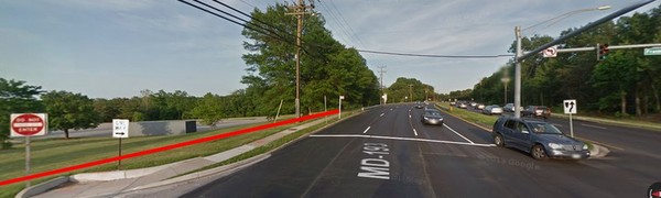
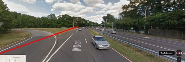
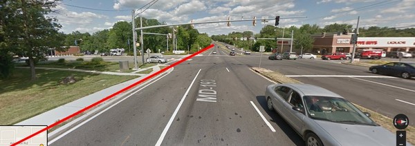
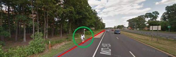
Here are some slides showing roughly where the trail would go and where intersections would need crosswalk improvements:
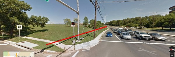
Trail starts at Hanover Parkway.
Trail can go behind light poles or expand sidewalk to multi-use trail width.

Expand sidewalk to 10′ for multi-use trail; narrow main travel lanes by 1′ each and push curb in 3′ to make room.

Need to pull guardrails and repurpose long acceleration and deceleration lanes for the trail.

Plenty of shoulder room for a protected trail.
High-speed ramps need to be squared off and calmed for safe trail crossing.

Trail would (slightly) help access Greenbelt’s most dangerous bus stop.

Need to square off and calm the high-speed “interchange” at ICESat Road so the trail can cross safely.

Cipriano Road intersection needs crosswalk to get to the strip mall.
Goddard main gate.

Need to repurpose the deceleration lane.

The trail continues to business park at Good Luck Road
Bus access should be safe. This is not safe.

Trail ends at Good Luck (crossing the street) Road.


John
Jeff, this is somewhat tangential, but related to bike/ped use of Greenbelt Rd. Buried in this article about funding for the new Beltway interchange at the metro is a line indicating the project will include re-building the Beltway bridge over route 193. This would be a good opportunity to improve on the horrible sidewalk under the bridge.
http://www.thesentinel.com/pgs/index.php?option=com_k2&view=item&id=1413:more-money-needed-for-fbi&Itemid=766
Mara
Fantastic proposal!
Bob Cochran
Thank you, Jeff. I biked all of the proposed route this morning to give it further thought. I like your proposal and think it is reasonable. I have not been involved in bike trail planning or proposals and this is a new experience for me. Perhaps you can update the wikimap as you see fit and I’ll seek to learn from you and others. Thank you for mentioning the advocacy group. I may go to the next meeting to help my learning process.
RE
Great idea. You should submit this idea to GGW if you have not already. I wonder is NASA would give up a little land or right of way to make this happen if need be.
RE
Great idea. You should submit this idea to GGW if you have not already.
RE
Great idea. You should submit this idea to GGW if you have not already.
Bob Cochran
I really like this idea. I’ve biked along this road more than a few times and the high speed traffic is indeed intimidating. I would like to see a proposed trail extend further, to connect to the WB & A Trail at the Glenn Dale Recreation Center.
Jeff
Bob and SM — Thanks, and I agree that the trail should extend down the WB&A. Would be a great amenity for Prince George’s County and for off-road connectivity for the region.
PGParks/MNCPPC is currently updating their bike trail master plan. Here’s the website:
http://www.pgparks.com/About-Parks-and-Recreation/New_Projects/Trails_Master_Plan_for_Prince_George_s_County_Park_System.htm
They have a link to a wiki map where you can draw in suggestions. This is a good one that I’ll draw in (or you can).
WABA also has a Prince George’ County advocacy group that is very helpful. We have a Google Group for staying in touch, and meet on the 2nd Tuesday of each month at Hyattsville Town Hall. We adjourn to Franklins for dinner and beverages after our meetings!
http://www.waba.org/advocacy/action-committees/
Jeff
SM
Brilliant!